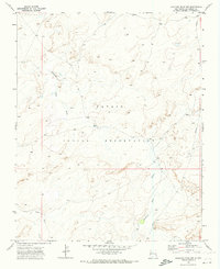
1970 Map of Standing Rock NW
USGS Topo · Published 1973About this map
The Navajo Indian Reservation landscape is defined by its drainage patterns and subterranean infrastructure in this 1970s survey. The map details the winding path of Standing Rock Wash as it travels through the high terrain, joined by the smaller Soft Water Wash. This arid region shows little in the way of permanent structures, but the presence of a Well and a prominent Pipeline running through the eastern portion of the quadrangle highlights the critical importance of water management and industrial transit in McKinley County during this era. Surveyed in 1969 and field-checked in 1970, this sheet provides a high-resolution look at the geographic character of the reservation before significant modern development.
Find a feature on this map
7 named features on this map. Tap any name to fly to it.
Don’t see what you’re looking for? This feature index may not catch every label — zoom into the map to look around manually.
Map Details
Editions of this 1970 Standing Rock NW Map
This is the sole edition of this map. No revisions or reprints were ever made.
Other maps of this area

1886 · Wingate
USGS Topo · 1:250,000

1889 · Chaco
USGS Topo · 1:250,000

1892 · Wingate
USGS Topo · 1:250,000

1892 · Chaco
USGS Topo · 1:250,000

1954 · Shiprock
USGS Topo · 1:250,000

1954 · Gallup
USGS Topo · 1:250,000

1958 · Gallup
USGS Topo · 1:250,000

1958 · Shiprock
USGS Topo · 1:250,000

1959 · Shiprock
USGS Topo · 1:250,000

1959 · Gallup
USGS Topo · 1:250,000