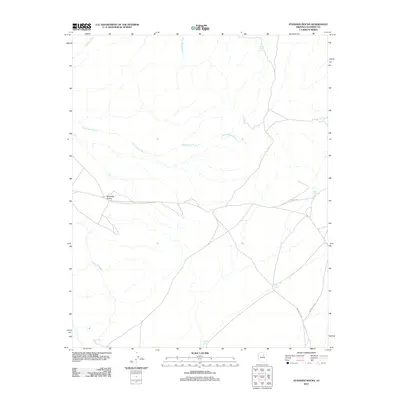
2011 Map of Standing Rocks
USGS Topo · Published 2011About this map
Standing Rocks anchor this Coconino County landscape, where the seasonal drainage network of the Painted Desert region is mapped in high detail. The terrain is defined by a series of ephemeral watercourses including White Water Wash, Sei Haasgaii Wash, and Badger Wash, which illustrate the complex erosion patterns of the Arizona plateau. For those researching the infrastructure of the Navajo Nation in the early 21st century, the map documents a vital network of livestock water sources such as Lii Haditiih Tank, Kish Zhini Tank, and the curiously named No Water Tank. Modern transport is represented by Indian Rte 6730 and Indian Rte 6732, which traverse the southern and eastern portions of the quadrangle. Other permanent water markers like Box Spring provide insight into the scattered reliable water points essential for life in this arid environment.
Find a feature on this map
14 named features on this map. Tap any name to fly to it.
Don’t see what you’re looking for? This feature index may not catch every label — zoom into the map to look around manually.
Map Details
Editions of this 2011 Standing Rocks Map
This is the sole edition of this map. No revisions or reprints were ever made.
Other maps of this area

1886 · San Francisco Mtns
USGS Topo · 1:250,000

1891 · San Francisco Mtns
USGS Topo · 1:250,000

1894 · San Francisco Mtns
USGS Topo · 1:250,000

1899 · San Francisco Mtns
USGS Topo · 1:250,000

1947 · Flagstaff
USGS Topo · 1:250,000

1954 · Flagstaff
USGS Topo · 1:250,000

1955 · Grand Falls NE
USGS Topo · 1:24,000

1955 · Black Falls 4 SW
USGS Topo · 1:24,000

1955 · Black Falls NE
USGS Topo · 1:24,000
1955 · Black Falls 4 SE
USGS Topo · 1:24,000