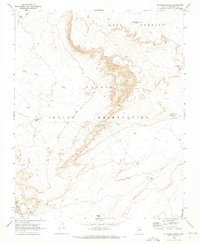
1969 Map of Standing Rocks
USGS Topo · Published 1973About this map
Navajo Indian Reservation lands dominate this late 1960s landscape, characterized by dramatic escarpments and specialized water management in an arid environment. The towering Tloi Eechii Cliffs and the broad Ward Terrace define the local topography, creating a natural barrier that separates the various drainage basins. Grounded in the necessities of high-desert life, the map documents numerous livestock and water features, including the curiously named Natani Well No Water Tank, as well as Kish Zhini Tank and Lii Haadiitah Tank.
Find a feature on this map
19 named features on this map. Tap any name to fly to it.
Don’t see what you’re looking for? This feature index may not catch every label — zoom into the map to look around manually.
Map Details
Editions of this 1969 Standing Rocks Map
This is the sole edition of this map. No revisions or reprints were ever made.
Other maps of this area

1886 · San Francisco Mtns
USGS Topo · 1:250,000

1891 · San Francisco Mtns
USGS Topo · 1:250,000

1894 · San Francisco Mtns
USGS Topo · 1:250,000

1899 · San Francisco Mtns
USGS Topo · 1:250,000

1947 · Flagstaff
USGS Topo · 1:250,000

1954 · Flagstaff
USGS Topo · 1:250,000

1955 · Grand Falls NE
USGS Topo · 1:24,000

1955 · Black Falls 4 SW
USGS Topo · 1:24,000

1955 · Black Falls NE
USGS Topo · 1:24,000
1955 · Black Falls 4 SE
USGS Topo · 1:24,000