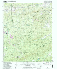
1997 Map of Standingstone Mtn
USGS Topo · Published 2001About this map
The dramatic fall line of the Blue Ridge escarpment is the defining characteristic of this landscape on the border of North and South Carolina. The Little Little River descends through a series of significant vertical drops, including High Falls, Bridal Veil Falls, Triple Falls, and Hooker Falls. These geological features shaped the recreational development of the area in the mid-to-late 20th century. By the time of this 1997 inspection, the region had become a hub for organized youth camps, most notably Camp Blue Star and Wabak Camp. The map illustrates how the rugged terrain influenced site selection for these institutions, placing them near established water features while maintaining the isolation required for wilderness retreats. The lack of major culture changes between the original 1962 topography and the 1997 imagery confirms a period of conservation and stable land use across these wooded heights.
Find a feature on this map
7 named features on this map. Tap any name to fly to it.
Don’t see what you’re looking for? This feature index may not catch every label — zoom into the map to look around manually.
Map Details
Editions of this 1997 Standingstone Mtn Map
This is the sole edition of this map. No revisions or reprints were ever made.
Other maps of this area

1905 · Pisgah
USGS Topo · 1:125,000

1906 · Pisgah
USGS Topo · 1:125,000

1907 · Saluda
USGS Topo · 1:125,000

1935 · Brevard
USGS Topo · 1:24,000

1935 · Standingstone Mtn.
USGS Topo · 1:24,000

1935 · Horse Shoe
USGS Topo · 1:24,000

1935 · Hendersonville
USGS Topo · 1:24,000

1935 · Table Rock
USGS Topo · 1:24,000

1935 · Zirconia
USGS Topo · 1:24,000

1935 · Pisgah Forest
USGS Topo · 1:24,000
Featured Places
- Jeter Mountain Terrace, NC
- Greenville County, SC
- Henderson County, NC
- Transylvania County, NC
- United States