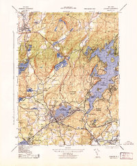
1943 Map of Stanhope
USGS Topo · Published 1943About this map
Lake Hopatcong dominates the eastern half of this 1943 survey, its intricate shoreline defined by places like Bertrand Island and Halsey Island. The landscape reflects a complex industrial and transport history, most notably the Morris Canal (Abandoned) which once served as a vital freight artery. The rail-heavy corridor through Stanhope and Netcong is anchored by the Delaware Lackawanna and Western and the Sussex Branch, showing the region's role as a transit hub between the highland lakes and the manufacturing centers of North Jersey.
Find a feature on this map
64 named features on this map. Tap any name to fly to it.
Don’t see what you’re looking for? This feature index may not catch every label — zoom into the map to look around manually.
Map Details
Editions of this 1943 Stanhope Map
This is the sole edition of this map. No revisions or reprints were ever made.
Other maps of this area

1888 · Franklin
USGS Topo · 1:62,500

1888 · Hackettstown
USGS Topo · 1:62,500

1888 · Lake Hopatcong
USGS Topo · 1:62,500

1891 · Wallpack
USGS Topo · 1:62,500

1893 · Wallpack
USGS Topo · 1:62,500

1894 · Hackettstown
USGS Topo · 1:62,500

1894 · Lake Hopatcong
USGS Topo · 1:62,500

1894 · Franklin
USGS Topo · 1:62,500

1897 · Franklin
USGS Topo · 1:62,500

1898 · Lake Hopatcong
USGS Topo · 1:62,500