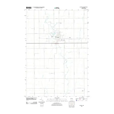
2010 Map of Stanley
USGS Topo · Published 2010About this map
The Stanley community serves as the primary hub of this 2010 topographic record, situated where the Wolf River meets the industrial history of the Stanley Mill Dam. The landscape is characterized by a dense network of county highways and agricultural corridors, such as County Hwy-O and County Hwy-X, which connect the town to outlying landmarks. Genealogists will find a high concentration of burial grounds surrounding the settlement, including Evergreen Cemetery, East Side Cemetery, Saint Marys Cemetery, and Oakland Cemetery, indicating a well-established and stable community footprint. To the south, the terrain opens into a series of watercourses like Swim Creek and Roger Creek, while the town center remains anchored by the Stanley Post Office and the recreation area around Chapman Lake. The map illustrates the persistent intersection of water-driven industry and the rural road grid in Chippewa County.
Find a feature on this map
47 named features on this map. Tap any name to fly to it.
Don’t see what you’re looking for? This feature index may not catch every label — zoom into the map to look around manually.
Map Details
Editions of this 2010 Stanley Map
This is the sole edition of this map. No revisions or reprints were ever made.
Other maps of this area

1951 · Cornell
USGS Topo · 1:62,500

1951 · Gilman
USGS Topo · 1:62,500

1952 · Cadott
USGS Topo · 1:62,500

1952 · Stanley
USGS Topo · 1:62,500

1953 · Eau Claire
USGS Topo · 1:250,000

1953 · Rice Lake
USGS Topo · 1:250,000

1958 · Eau Claire
USGS Topo · 1:250,000

1959 · Rice Lake
USGS Topo · 1:250,000

1964 · Eau Claire
USGS Topo · 1:250,000
1973 · Colburn
USGS Topo · 1:24,000