1997 Map of Stanley
USGS Topo · Published 2000About this map
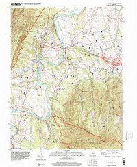
The South Fork Shenandoah River winds through the heart of this Page County landscape, serving as a historic corridor for settlements like Ingham, Grove Hill, and Leaksville. In the valley floor, rural life is anchored by gathering places such as St Pauls Ch, Leake Chapel, and St Lukes Ch, while the County High Sch sits near the town of Stanley. The river's influence on local commerce and transport is marked by Grove Hill Landing, providing a clear look at how water access shaped this section of the Shenandoah Valley.
Find a feature on this map
47 named features on this map. Tap any name to fly to it.
Don’t see what you’re looking for? This feature index may not catch every label — zoom into the map to look around manually.
Map Details
Editions of this 1997 Stanley Map
This is the sole edition of this map. No revisions or reprints were ever made.
Other maps of this area

1892 · Woodstock
USGS Topo · 1:125,000

1892 · Gordonsville
USGS Topo · 1:125,000

1892 · Harrisonburg
USGS Topo · 1:125,000

1893 · Luray
USGS Topo · 1:125,000

1905 · Luray
USGS Topo · 1:125,000

1929 · Stony Man
USGS Topo · 1:48,000

1930 · Madison
USGS Topo · 1:48,000

1933 · Stony Man
USGS Topo · 1:62,500

1933 · Madison
USGS Topo · 1:62,500

1937 · Elkton
USGS Topo · 1:62,500