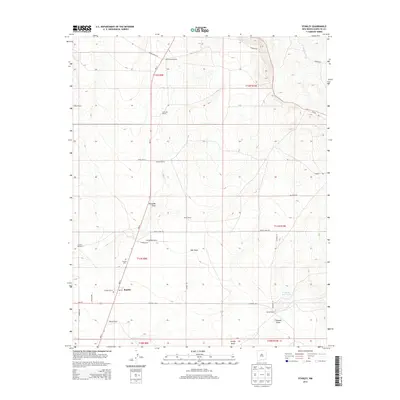
2013 Map of Stanley
USGS Topo · Published 2013About this map
Stanley serves as the central hub for this high-desert ranching landscape in Santa Fe County, shown here in the early twenty-first century. The map illustrates a pattern of dispersed agricultural settlement, with numerous family-named properties like the Fisher Ranch, Godec Ranch, and Kinsell Ranch connected by a network of rural roads including White Lakes Rd and NM-41. The arid environment is defined by its drainage systems, such as Salt Draw, Kinsell Draw, and Kamradt Draw, alongside essential water infrastructure like the K and R Reservoir and the Landon Windmill. For genealogists and local historians, the Stanley Cem and the town's Po provide specific points of interest for tracing the community's footprint. The grid-like organization of the landscape into townships and ranges, such as t11n r9e, underscores the systematic land use that continues to shape this region.
Find a feature on this map
38 named features on this map. Tap any name to fly to it.
Don’t see what you’re looking for? This feature index may not catch every label — zoom into the map to look around manually.
Map Details
Editions of this 2013 Stanley Map
This is the sole edition of this map. No revisions or reprints were ever made.
Other maps of this area

1892 · San Pedro
USGS Topo · 1:125,000

1894 · Lamy
USGS Topo · 1:125,000

1954 · Santa Fe
USGS Topo · 1:250,000

1956 · Edgewood
USGS Topo · 1:62,500

1958 · Santa Fe
USGS Topo · 1:250,000

1958 · Albuquerque
USGS Topo · 1:250,000

1960 · Stanley
USGS Topo · 1:62,500

1961 · Madrid
USGS Topo · 1:62,500

1962 · Albuquerque
USGS Topo · 1:250,000
1963 · Albuquerque
USGS Topo · 1:250,000