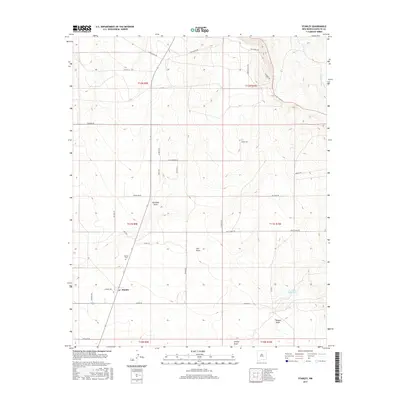
2017 Map of Stanley
USGS Topo · Published 2017About this map
Stanley serves as the central hub of this high plains settlement in southern Santa Fe County. The landscape is defined by a series of drainage systems, most notably Kamradt Draw and Salt Draw, which flow through the arid terrain. Local genealogy is anchored by the Stanley Cem, while the regional ranching economy is evident through the extensive network of private and county roads such as Zorro Ranch Rd, King Ranch Rd, and Green Ranch Rd. Further south, Kinsell Draw and Armijo Draw carve through the open country. This survey illustrates a modern rural layout where traditional ranching boundaries intersect with newer residential developments like Via Compostela and the evocative Calamity Ln, showing how the Santa Fe hinterland continues to adapt to its environment.
Find a feature on this map
39 named features on this map. Tap any name to fly to it.
Don’t see what you’re looking for? This feature index may not catch every label — zoom into the map to look around manually.
Map Details
Editions of this 2017 Stanley Map
This is the sole edition of this map. No revisions or reprints were ever made.
Other maps of this area

1892 · San Pedro
USGS Topo · 1:125,000

1894 · Lamy
USGS Topo · 1:125,000

1954 · Santa Fe
USGS Topo · 1:250,000

1956 · Edgewood
USGS Topo · 1:62,500

1958 · Santa Fe
USGS Topo · 1:250,000

1958 · Albuquerque
USGS Topo · 1:250,000

1960 · Stanley
USGS Topo · 1:62,500

1961 · Madrid
USGS Topo · 1:62,500

1962 · Albuquerque
USGS Topo · 1:250,000
1963 · Albuquerque
USGS Topo · 1:250,000