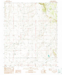
1990 Map of Stanley
USGS Topo · Published 1990About this map
Stanley serves as the focal point of this Santa Fe County landscape, situated where the drainage patterns of the high desert converge. The terrain is defined by a network of seasonal watercourses, including Big Draw and Kamradt Draw, which carve through the open country. To the northeast, the land rises toward the distinctive Redondo and the broad expanse of Valle San Cristoval. This 1990 provisional map reflects a rural environment where infrastructure is sparse, limited primarily to water management features like the Kond R Reservoir and various water tanks. Local history and genealogy are anchored by the Stanley Cemetery and the Landon Windmill, marking long-standing family and ranching footprints in the region. The map also records the presence of a Radio Tower and industrial sites such as a Gravel Pit, indicating the modest technological and commercial layers added to this traditional ranching territory.
Find a feature on this map
19 named features on this map. Tap any name to fly to it.
Don’t see what you’re looking for? This feature index may not catch every label — zoom into the map to look around manually.
Map Details
Editions of this 1990 Stanley Map
This is the sole edition of this map. No revisions or reprints were ever made.
Other maps of this area

1892 · San Pedro
USGS Topo · 1:125,000

1894 · Lamy
USGS Topo · 1:125,000

1954 · Santa Fe
USGS Topo · 1:250,000

1956 · Edgewood
USGS Topo · 1:62,500

1958 · Santa Fe
USGS Topo · 1:250,000

1958 · Albuquerque
USGS Topo · 1:250,000

1960 · Stanley
USGS Topo · 1:62,500

1961 · Madrid
USGS Topo · 1:62,500

1962 · Albuquerque
USGS Topo · 1:250,000
1963 · Albuquerque
USGS Topo · 1:250,000