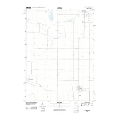
2010 Map of Stanwood
USGS Topo · Published 2010About this map
Mechanicsville and Stanwood anchor the southern half of this Cedar County landscape, where the modern road network preserves the route of the Old Lincoln Hwy. The terrain is defined by a dendritic drainage system including Walnut Creek, Pioneer Creek, and Rock Creek, which flow through a predominantly agricultural grid. In the northeast, the settlement of Olin sits near the Olin Access and Olin Post Office, with the Olin Cemetery located just to the south. This survey captures the rural continuity of the region, documenting the relationship between these small towns and the surrounding township roads like Cedar Jones Rd and Monroe Ave. For genealogists, the map provides precise locations for both the Stanwood Cemetery and its counterpart in Olin, alongside vital community landmarks like the Stanwood Post Office.
Find a feature on this map
45 named features on this map. Tap any name to fly to it.
Don’t see what you’re looking for? This feature index may not catch every label — zoom into the map to look around manually.
Map Details
Editions of this 2010 Stanwood Map
This is the sole edition of this map. No revisions or reprints were ever made.
Other maps of this area

1889 · Tipton
USGS Topo · 1:62,500

1890 · Tipton
USGS Topo · 1:62,500

1890 · Anamosa
USGS Topo · 1:62,500

1891 · Monticello
USGS Topo · 1:62,500

1891 · Mechanicsville
USGS Topo · 1:62,500

1894 · Mechanicsville
USGS Topo · 1:62,500

1900 · Anamosa
USGS Topo · 1:125,000

1901 · Stanwood
USGS Topo · 1:125,000
1953 · Tipton East
USGS Topo · 1:24,000

1958 · Davenport
USGS Topo · 1:250,000