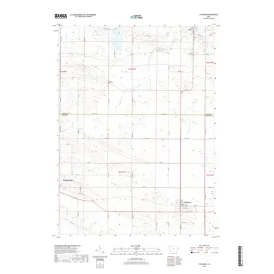
2018 Map of Stanwood
USGS Topo · Published 2018About this map
Mechanicsville and Stanwood anchor this agricultural landscape along the southern border of the Jones Co and Cedar Co line. The terrain is defined by a dendritic network of small waterways, including Sibles Cr, Pioneer Cr, and Walnut Cr, which have shaped the local topography into a series of low ridges and valleys. Evidence of the region's early automotive history is preserved in the route of the Old Lincoln Hwy, which passes just south of Mechanicsville. This section of East Central Iowa maintains a traditional grid of section lines and gravel roads, with family and community history visible in the placement of Walnut Grove Cem and Stanwood Cem. To the north, the town of Olin sits near the upper edge of the survey, where Jackson St and Maple St mark the local street plan.
Find a feature on this map
51 named features on this map. Tap any name to fly to it.
Don’t see what you’re looking for? This feature index may not catch every label — zoom into the map to look around manually.
Map Details
Editions of this 2018 Stanwood Map
This is the sole edition of this map. No revisions or reprints were ever made.
Other maps of this area

1889 · Tipton
USGS Topo · 1:62,500

1890 · Tipton
USGS Topo · 1:62,500

1890 · Anamosa
USGS Topo · 1:62,500

1891 · Monticello
USGS Topo · 1:62,500

1891 · Mechanicsville
USGS Topo · 1:62,500

1894 · Mechanicsville
USGS Topo · 1:62,500

1900 · Anamosa
USGS Topo · 1:125,000

1901 · Stanwood
USGS Topo · 1:125,000
1953 · Tipton East
USGS Topo · 1:24,000

1958 · Davenport
USGS Topo · 1:250,000