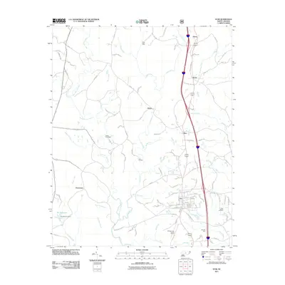
2011 Map of Star
USGS Topo · Published 2011About this map
Star serves as the central hub of this North Carolina survey, situated at the intersection of several local routes in Montgomery County. The landscape is defined by the dendritic drainage patterns of the Little River and the West Fork Little River, which are fed by numerous smaller creeks such as Suggs Creek, Rocky Creek, and Williams Creek. This 2011 map documents the area during a period of established aviation and local industry, featuring the Montgomery County Airport and the Black Ankle Mine in the northern reaches. Settlement patterns follow the historical corridors of Old US Highway 220, connecting the communities of Asbury, Steeds, Ether, and Allreds. Genealogists and local historians can locate established landmarks like the Allen Cemetery and New Hope Cemetery, as well as the Troy Reservoirs and several dam sites including Ott Lake Dam and Foster Pond Dam.
Find a feature on this map
102 named features on this map. Tap any name to fly to it.
Don’t see what you’re looking for? This feature index may not catch every label — zoom into the map to look around manually.
Map Details
Editions of this 2011 Star Map
This is the sole edition of this map. No revisions or reprints were ever made.
Other maps of this area

1942 · Troy
USGS Topo · 1:125,000

1953 · Raleigh
USGS Topo · 1:250,000

1954 · Raleigh
USGS Topo · 1:250,000

1957 · Troy
USGS Topo · 1:62,500

1957 · Asheboro
USGS Topo · 1:62,500

1968 · Erect
USGS Topo · 1:24,000
1973 · Eleazer
USGS Topo · 1:24,000

1973 · Seagrove
USGS Topo · 1:24,000

1974 · Candor
USGS Topo · 1:24,000
1977 · Spies
USGS Topo · 1:24,000