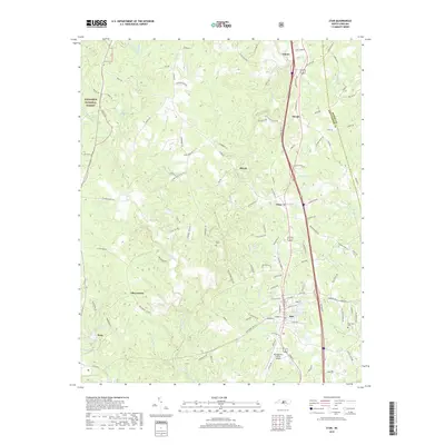
2019 Map of Star
USGS Topo · Published 2019About this map
The town of Star serves as a central hub on this 2019 survey, where the Norfolk Southern railway parallels the highway corridor through the heart of Montgomery County. To the west, the dense woodlands of the Uwharrie National Forest dominate the terrain, dissected by the W Fork Little River and its numerous tributaries like Black Rock Br and Gold Mine Br. The landscape is a mix of protected forest, small agricultural holdings, and rural settlements including Asbury, Steeds, and Ether.
Find a feature on this map
126 named features on this map. Tap any name to fly to it.
Don’t see what you’re looking for? This feature index may not catch every label — zoom into the map to look around manually.
Map Details
Editions of this 2019 Star Map
This is the sole edition of this map. No revisions or reprints were ever made.
Other maps of this area

1942 · Troy
USGS Topo · 1:125,000

1953 · Raleigh
USGS Topo · 1:250,000

1954 · Raleigh
USGS Topo · 1:250,000

1957 · Troy
USGS Topo · 1:62,500

1957 · Asheboro
USGS Topo · 1:62,500

1968 · Erect
USGS Topo · 1:24,000
1973 · Eleazer
USGS Topo · 1:24,000

1973 · Seagrove
USGS Topo · 1:24,000

1974 · Candor
USGS Topo · 1:24,000
1977 · Spies
USGS Topo · 1:24,000