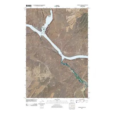
2011 Map of Starbuck West
USGS Topo · Published 2011About this map
The Snake River and its major tributaries, the Palouse River and Tucannon River, converge in this corner of Columbia County. The landscape is defined by the massive Lake Herbert G West Reservation Area, which pools behind Lyons Dam. Along the northern banks, the Marmes Rock Shelter and Old Bones Cemetery indicate the deep human history of the river bluffs. In the southeastern corner, the town of Starbuck serves as a local hub near Kellogg Creek, with its street grid including Railroad St and Lauren St. The map also documents agricultural life through named homesteads like Fletcher Farm and Tucker Farm, while river crossings and settlements such as Perry, Joso, and Pataha mark the transit corridors of the inland Northwest.
Find a feature on this map
28 named features on this map. Tap any name to fly to it.
Don’t see what you’re looking for? This feature index may not catch every label — zoom into the map to look around manually.
Map Details
Editions of this 2011 Starbuck West Map
This is the sole edition of this map. No revisions or reprints were ever made.
Other maps of this area

1919 · Walla Walla
USGS Topo · 1:125,000

1921 · Walla Walla
USGS Topo · 1:125,000

1948 · Starbuck
USGS Topo · 1:62,500

1948 · Ayer
USGS Topo · 1:62,500

1950 · Starbuck
USGS Topo · 1:62,500

1950 · Haas
USGS Topo · 1:62,500

1953 · Walla Walla
USGS Topo · 1:250,000

1958 · Walla Walla
USGS Topo · 1:250,000

1967 · Waitsburg NW
USGS Topo · 1:24,000
1967 · Kellogg Creek
USGS Topo · 1:24,000