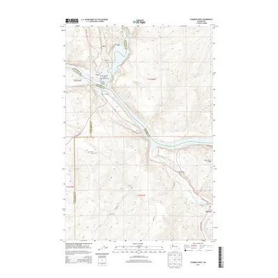
2013 Map of Starbuck West
USGS Topo · Published 2013About this map
Palouse River and Snake River converge in this corner of Washington, forming a landscape shaped by significant water systems and the infrastructure required to cross them. The Lyons Ferry Bridge and nearby Lyons Ferry Marina serve as central landmarks where Franklin, Whitman, and Columbia counties meet. Further inland, the map captures agricultural and archaeological points of interest, including the Marmes Rock Shelter and the curiously named Old Bones Cem north of Perry. Small settlements and family holdings like Powers, Fletcher Farm, and Tucker Farm are scattered along the local road network, including Wa-261. In the southeastern corner, the town of Starbuck sits at the junction of the Tucannon River and Kellogg Cr, with its street grid including Railroad St and Baxter St clearly defined against the rising terrain of Choke Cherry Canyon.
Find a feature on this map
36 named features on this map. Tap any name to fly to it.
Don’t see what you’re looking for? This feature index may not catch every label — zoom into the map to look around manually.
Map Details
Editions of this 2013 Starbuck West Map
This is the sole edition of this map. No revisions or reprints were ever made.
Other maps of this area

1919 · Walla Walla
USGS Topo · 1:125,000

1921 · Walla Walla
USGS Topo · 1:125,000

1948 · Starbuck
USGS Topo · 1:62,500

1948 · Ayer
USGS Topo · 1:62,500

1950 · Starbuck
USGS Topo · 1:62,500

1950 · Haas
USGS Topo · 1:62,500

1953 · Walla Walla
USGS Topo · 1:250,000

1958 · Walla Walla
USGS Topo · 1:250,000

1967 · Waitsburg NW
USGS Topo · 1:24,000
1967 · Kellogg Creek
USGS Topo · 1:24,000