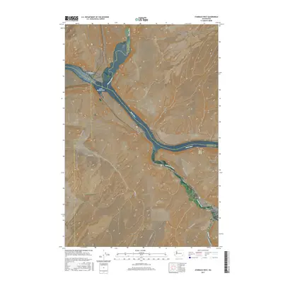
2017 Map of Starbuck West
USGS Topo · Published 2017About this map
Starbuck anchors the southeast corner of this Columbia County landscape, situated near the confluence of the Snake River and the Tucannon River. The region is defined by the dramatic meeting of these major waterways, where the Palouse River also joins from the north near Joso. This complex aquatic junction has historically shaped transportation and settlement, evidenced by the Lyons Ferry Bridge spanning the wide waters of Lake Herbert G West.
Find a feature on this map
30 named features on this map. Tap any name to fly to it.
Don’t see what you’re looking for? This feature index may not catch every label — zoom into the map to look around manually.
Map Details
Editions of this 2017 Starbuck West Map
This is the sole edition of this map. No revisions or reprints were ever made.
Other maps of this area

1919 · Walla Walla
USGS Topo · 1:125,000

1921 · Walla Walla
USGS Topo · 1:125,000

1948 · Starbuck
USGS Topo · 1:62,500

1948 · Ayer
USGS Topo · 1:62,500

1950 · Starbuck
USGS Topo · 1:62,500

1950 · Haas
USGS Topo · 1:62,500

1953 · Walla Walla
USGS Topo · 1:250,000

1958 · Walla Walla
USGS Topo · 1:250,000

1967 · Waitsburg NW
USGS Topo · 1:24,000
1967 · Kellogg Creek
USGS Topo · 1:24,000