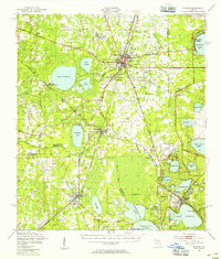
1949 Map of Starke
USGS Topo · Published 1955About this map
The railroad junction at Starke serves as the focal point for this mid-century survey of North Central Florida, where the Seaboard Air Line and Southern tracks intersect. The landscape is defined by its extensive lake systems, including the massive Lake Sampson, Kingsley Lake, and the connected waters of Lake Geneva and Santa Fe Lake to the south. Notable industrial activity is captured at the Trail Ridge Mine and the Pumphouse near the Mobile Target Range, reflecting the post-war development of the region's natural resources and military facilities.
Find a feature on this map
70 named features on this map. Tap any name to fly to it.
Don’t see what you’re looking for? This feature index may not catch every label — zoom into the map to look around manually.
Map Details
Editions of this 1949 Starke Map
2 editions found

Other maps of this area

1890 · Arredondo
USGS Topo · 1:62,500

1892 · Arredondo
USGS Topo · 1:62,500

1894 · Arredondo
USGS Topo · 1:62,500

1915 · Interlachen
USGS Topo · 1:48,000

1916 · Interlachen
USGS Topo · 1:62,500

1918 · Middleburg
USGS Topo · 1:62,500

1918 · Lawtey
USGS Topo · 1:62,500

1938 · Hawthorn
USGS Topo · 1:48,000

1941 · Starke
USGS Topo · 1:62,500

1941 · Middleburg
USGS Topo · 1:62,500