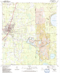
1991 Map of Starke
USGS Topo · Published 1991About this map
The town of Starke serves as the focal point of this 1991 document, situated at the intersection of several regional travel corridors. The town's infrastructure is well-defined, showing the Courthouse, local schools like Southside Sch, and a dense network of spiritual centers including New Hope Ch and Bethlehem Mem Cem. To the east, the landscape shifts dramatically into the Camp Blanding State Wildlife Management Area, where the industrial scale of Strip Mines and the Trail Ridge Mine contrast with the natural expanse of Kingsley Lake and the wetlands of Hells Morass. This transition between the residential core and large-scale extraction sites reflects the area's dual identity as a county seat and a center for heavy mineral mining. Smaller settlements such as Lincoln City and Kingsley Village offer points of interest for those tracking local development and residential patterns across the Bradford and Clay county line.
Find a feature on this map
48 named features on this map. Tap any name to fly to it.
Don’t see what you’re looking for? This feature index may not catch every label — zoom into the map to look around manually.
Map Details
Editions of this 1991 Starke Map
This is the sole edition of this map. No revisions or reprints were ever made.
Other maps of this area

1918 · Middleburg
USGS Topo · 1:62,500

1918 · Lawtey
USGS Topo · 1:62,500

1941 · Starke
USGS Topo · 1:62,500

1941 · Middleburg
USGS Topo · 1:62,500

1942 · Ates Creek
USGS Topo · 1:62,500

1948 · Starke
USGS Topo · 1:50,000

1948 · Jacksonville
USGS Topo · 1:250,000

1949 · Middleburg SW
USGS Topo · 1:24,000

1949 · Sampson
USGS Topo · 1:24,000

1949 · Gold Head Branch
USGS Topo · 1:24,000