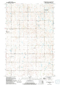
1994 Map of Starkweather NE
USGS Topo · Published 1994About this map
Starkweather serves as the primary hub in this corner of Ramsey County, where the grid of the northern plains meets the irregular hydrology of the Devils Lake Basin. This 1994 update reveals a landscape organized by township sections including Klingstrup, Royal, Hammer, and Sullivan. The terrain is characterized by numerous prairie potholes and wetlands, many of which are protected within the National Waterfowl Production Area. Transportation and local infrastructure are marked by the Hofstad Landing Strip and several burial sites that anchor the community's history, such as Calvary Cem and Starkweather Cem. The drainage of Starkweather Coulee meanders through the eastern townships, illustrating the natural water management patterns essential to this agricultural region during the late twentieth century.
Find a feature on this map
12 named features on this map. Tap any name to fly to it.
Don’t see what you’re looking for? This feature index may not catch every label — zoom into the map to look around manually.
Map Details
Editions of this 1994 Starkweather NE Map
This is the sole edition of this map. No revisions or reprints were ever made.
Other maps of this area

1953 · Devils Lake
USGS Topo · 1:250,000

1956 · Devils Lake
USGS Topo · 1:250,000

1957 · Starkweather SE
USGS Topo · 1:24,000

1957 · Webster
USGS Topo · 1:24,000

1962 · Starkweather
USGS Topo · 1:24,000

1962 · Starkweather NE
USGS Topo · 1:24,000

1970 · Hampden
USGS Topo · 1:24,000

1971 · Munich SW
USGS Topo · 1:24,000

1971 · Munich SE
USGS Topo · 1:24,000

1972 · Derrick NW
USGS Topo · 1:24,000