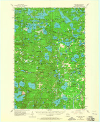
1955 Map of Starlake
USGS Topo · Published 1965About this map
Ottawa National Forest dominates the northern reaches of this mid-century landscape, where the state boundary between Michigan and Wisconsin cuts through a dense network of glacial lakes. The settlement of Starlake sits at the southern edge of its namesake water body, while Conover serves as a small hub to the southeast. This survey, based on 1952 aerial photography and 1955 field checks, illustrates a region defined by recreational and conservation land use. Cultural landmarks like the Covenant Ch and the Oak O' Lakes Cem are recorded alongside natural features such as Siphon Springs and Garland Springs. Notable for local historians is the Indian Cem located near the shores of Lac du Lune, reflecting the long-standing indigenous presence in this lake-studded territory. The presence of a Lookout Tower near Tower Lake highlights the era's focus on forest fire management within these timbered lands.
Find a feature on this map
189 named features on this map. Tap any name to fly to it.
Don’t see what you’re looking for? This feature index may not catch every label — zoom into the map to look around manually.
Map Details
Editions of this 1955 Starlake Map
4 editions found

Other maps of this area

1928 · Three Lakes
USGS Topo · 1:48,000

1930 · Robbins
USGS Topo · 1:48,000

1938 · Phelps
USGS Topo · 1:48,000

1938 · Minocqua
USGS Topo · 1:48,000

1938 · Three Lakes
USGS Topo · 1:48,000

1938 · Robbins
USGS Topo · 1:48,000

1939 · Trout Lake
USGS Topo · 1:48,000

1945 · Three Lakes
USGS Topo · 1:48,000

1945 · Robbins
USGS Topo · 1:48,000

1946 · Star Lake
USGS Topo · 1:48,000