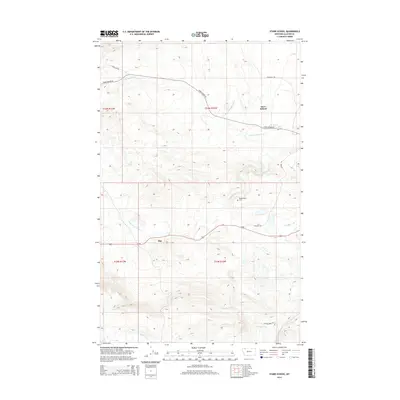
2014 Map of Starr School
USGS Topo · Published 2014About this map
The settlement of Starr School serves as a focal point in this high-plains landscape of Glacier County, situated amidst a complex network of waterways and irrigation infrastructure. The Cut Bank Greasewood Canal winds through the northern sections, cutting across the drainages of N Fork Cut Bank Cr and S Fork Cut Bank Cr. To the south, the community of Star lies along Us-89, a vital corridor through the Blackfeet Indian Reservation. Local genealogy is anchored by the Afterbuffalo Cem, while the rugged terrain is marked by numerous traditional routes including Flatiron Trl and Starr Flat Trl. The presence of these named trails and several prominent creeks, such as Flatiron Creek and Willow Cr, reflects a landscape defined by both modern highway transit and established ranching and irrigation patterns.
Find a feature on this map
19 named features on this map. Tap any name to fly to it.
Don’t see what you’re looking for? This feature index may not catch every label — zoom into the map to look around manually.
Map Details
Editions of this 2014 Starr School Map
This is the sole edition of this map. No revisions or reprints were ever made.
Other maps of this area

1901 · Browning
USGS Topo · 1:125,000

1903 · Browning
USGS Topo · 1:125,000

1913 · Marias Pass
USGS Topo · 1:125,000

1960 · Cut Bank
USGS Topo · 1:250,000

1963 · Cut Bank
USGS Topo · 1:250,000

1964 · Cut Bank
USGS Topo · 1:250,000

1968 · Josephine
USGS Topo · 1:24,000
1968 · Kiowa
USGS Topo · 1:24,000

1968 · Browning NE
USGS Topo · 1:24,000
1968 · Browning
USGS Topo · 1:24,000