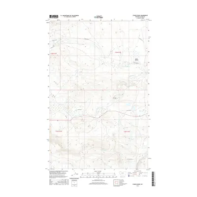
2017 Map of Starr School
USGS Topo · Published 2017About this map
Starr School serves as a central anchor in this landscape of northern Montana, situated along the Starr School Rd and Starr Flat Trl. The area is defined by its complex drainage network, where the N Fork Cut Bank Cr and S Fork Cut Bank Cr carve through the terrain. Human modification of the water system is evident in the Cut Bank Greasewood Canal, while local heritage is marked by the presence of Afterbuffalo Cem near the center of the sheet. Further south, Flatiron Creek and Willow Cr frame the lower reaches of the quadrangle. The map documents a sparsely populated but historically rooted area of Glacier County, featuring local roads and named paths such as Spotted Robe Trl and Many Hides Trl, which suggest a landscape shaped by long-standing transit patterns and community connections.
Find a feature on this map
20 named features on this map. Tap any name to fly to it.
Don’t see what you’re looking for? This feature index may not catch every label — zoom into the map to look around manually.
Map Details
Editions of this 2017 Starr School Map
This is the sole edition of this map. No revisions or reprints were ever made.
Other maps of this area

1901 · Browning
USGS Topo · 1:125,000

1903 · Browning
USGS Topo · 1:125,000

1913 · Marias Pass
USGS Topo · 1:125,000

1960 · Cut Bank
USGS Topo · 1:250,000

1963 · Cut Bank
USGS Topo · 1:250,000

1964 · Cut Bank
USGS Topo · 1:250,000

1968 · Josephine
USGS Topo · 1:24,000
1968 · Kiowa
USGS Topo · 1:24,000

1968 · Browning NE
USGS Topo · 1:24,000
1968 · Browning
USGS Topo · 1:24,000