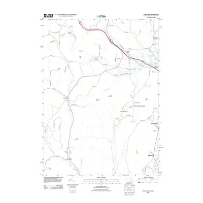
2012 Map of State Line
USGS Topo · Published 2012About this map
Richmond Furnace and the industrial heritage of the Berkshires anchor this landscape, where old mining sites like Hudson Ore Bed Pond and Leet Ore Bed Pond remain as clear water bodies. The terrain is marked by significant elevations including Harvey Mountain and Tom Ball Mountain, while the valleys host historic clusters such as Rockdale Mills and Williamsville along the Williams River. Local genealogy is well-supported by numerous burial grounds, including West Stockbridge Cem and Saint Patricks Cem. This 2012 survey illustrates the contemporary character of these rural communities, showing the persistence of traditional place names alongside modern recreational sites like Camp Kingsmont and Woodland Hills Campground. The mapping reveals a complex network of brooks, such as Baldwin Brook and Alford Brook, that shaped the early settlement patterns of the region.
Find a feature on this map
105 named features on this map. Tap any name to fly to it.
Don’t see what you’re looking for? This feature index may not catch every label — zoom into the map to look around manually.
Map Details
Editions of this 2012 State Line Map
This is the sole edition of this map. No revisions or reprints were ever made.
Other maps of this area

1885 · Sheffield
USGS Topo · 1:62,500

1888 · Sheffield
USGS Topo · 1:62,500

1888 · Pittsfield
USGS Topo · 1:62,500

1890 · Pittsfield
USGS Topo · 1:62,500

1891 · Sheffield
USGS Topo · 1:62,500

1893 · Sheffield
USGS Topo · 1:62,500

1893 · Pittsfield
USGS Topo · 1:62,500

1894 · Pittsfield
USGS Topo · 1:62,500

1897 · Pittsfield
USGS Topo · 1:62,500

1897 · Sheffield
USGS Topo · 1:62,500