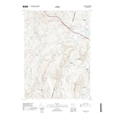
2018 Map of State Line
USGS Topo · Published 2018About this map
Richmond Furnace and State Line mark the northern corridor of this landscape straddling the New York and Massachusetts border. The topography is defined by significant elevations like Tom Ball Mtn and Harvey Mtn, which frame a network of drainages including the Green River and Alford Brook. Settlement patterns follow the valleys, where historic industrial sites like Rockdale Mills and extraction points such as Leet Ore Bed Pond indicate a history of local resource processing. Rural life is anchored by scattered communities like West Stockbridge Center and Austerlitz, with several family-named landmarks and cemeteries like Saint Patricks Cem and West Center Cem providing vital points of reference for genealogical research. The presence of recreational and seasonal sites, including Crane Lake Camp and Camp Kingsmont, reflects the transition of this highland area from its industrial roots toward a modern residential and leisure character.
Find a feature on this map
110 named features on this map. Tap any name to fly to it.
Don’t see what you’re looking for? This feature index may not catch every label — zoom into the map to look around manually.
Map Details
Editions of this 2018 State Line Map
This is the sole edition of this map. No revisions or reprints were ever made.
Other maps of this area

1885 · Sheffield
USGS Topo · 1:62,500

1888 · Sheffield
USGS Topo · 1:62,500

1888 · Pittsfield
USGS Topo · 1:62,500

1890 · Pittsfield
USGS Topo · 1:62,500

1891 · Sheffield
USGS Topo · 1:62,500

1893 · Sheffield
USGS Topo · 1:62,500

1893 · Pittsfield
USGS Topo · 1:62,500

1894 · Pittsfield
USGS Topo · 1:62,500

1897 · Pittsfield
USGS Topo · 1:62,500

1897 · Sheffield
USGS Topo · 1:62,500