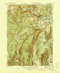
1946 Map of State Line
USGS Topo · Published 1946About this map
The New York Massachusetts border country is defined by the intersection of industrial transport and the high ridges of the Berkshires and Taconics in the mid-1940s. The village of State Line serves as a critical junction for the Boston and Albany railroad, while the legacy of early regional industry is visible at Richmond Furnace. The landscape is a network of steep elevations like Harvey Mtn and Mercer Mtn, interspersed with agricultural valleys and small crossroad settlements such as Austerlitz and West Stockbridge Center. Local education is anchored by rural landmarks like Red Rock Sch and Fog Hill Sch, serving a community tied to the hills and stream valleys of the Green River and Flat Brook. The map reveals a transition between the rail-dependent hamlets and the high, undeveloped summits like Tom Ball Mtn and Bald Mtn.
Find a feature on this map
62 named features on this map. Tap any name to fly to it.
Don’t see what you’re looking for? This feature index may not catch every label — zoom into the map to look around manually.
Map Details
Editions of this 1946 State Line Map
This is the sole edition of this map. No revisions or reprints were ever made.
Other maps of this area

1885 · Sheffield
USGS Topo · 1:62,500

1888 · Sheffield
USGS Topo · 1:62,500

1888 · Pittsfield
USGS Topo · 1:62,500

1890 · Pittsfield
USGS Topo · 1:62,500

1891 · Sheffield
USGS Topo · 1:62,500

1893 · Sheffield
USGS Topo · 1:62,500

1893 · Pittsfield
USGS Topo · 1:62,500

1894 · Pittsfield
USGS Topo · 1:62,500

1897 · Pittsfield
USGS Topo · 1:62,500

1897 · Sheffield
USGS Topo · 1:62,500