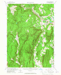
1959 Map of State Line
USGS Topo · Published 1967About this map
Richmond Furnace and the village of State Line serve as the primary hubs in this mid-century look at the border between New York and Massachusetts. The landscape is defined by the legacy of early industry and transport, where the New York Central and New York New Haven and Hartford railroads converge near modern infrastructure like the New York State Thruway. Remnants of the region's iron mining history are visible in names like Hudson Ore Bed Pond and Leet Ore Bed Pond, while local genealogy is anchored by the Austerlitz Cem, West Center Cem, and Rockdale Cem. From the heights of Harvey Mtn to the banks of the Williams River, the map documents a transition from old industrial hamlets to a landscape of small farms and summer camps like Silver Birch Camp.
Find a feature on this map
57 named features on this map. Tap any name to fly to it.
Don’t see what you’re looking for? This feature index may not catch every label — zoom into the map to look around manually.
Map Details
Editions of this 1959 State Line Map
2 editions found
Other maps of this area

1885 · Sheffield
USGS Topo · 1:62,500

1888 · Sheffield
USGS Topo · 1:62,500

1888 · Pittsfield
USGS Topo · 1:62,500

1890 · Pittsfield
USGS Topo · 1:62,500

1891 · Sheffield
USGS Topo · 1:62,500

1893 · Sheffield
USGS Topo · 1:62,500

1893 · Pittsfield
USGS Topo · 1:62,500

1894 · Pittsfield
USGS Topo · 1:62,500

1897 · Pittsfield
USGS Topo · 1:62,500

1897 · Sheffield
USGS Topo · 1:62,500