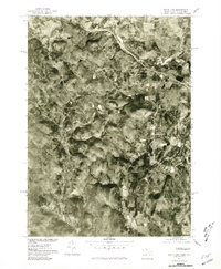
1975 Map of State Line
USGS Topo · Published 1981About this map
State Line and the border between Massachusetts and New York are captured here through mid-1970s aerial photography, revealing a landscape defined by sharp topographical ridges and narrow valley corridors. The settlement pattern follows these natural breaks, with West Stockbridge Center and Williamsville situated along the eastern drainage of the Williams River. In the southwest, the Green River carves a winding path past the community of Austerlitz, illustrating how early colonial-era boundaries and subsequent transportation routes were dictated by the rugged Berkshire and Taconic terrain. This orthophotoquad provides a direct visual record of land use and forest cover, showing the dense timber and cleared clearings near Housatonic just before the end of the 20th century.
Find a feature on this map
8 named features on this map. Tap any name to fly to it.
Don’t see what you’re looking for? This feature index may not catch every label — zoom into the map to look around manually.
Map Details
Editions of this 1975 State Line Map
This is the sole edition of this map. No revisions or reprints were ever made.
Other maps of this area

1885 · Sheffield
USGS Topo · 1:62,500

1888 · Sheffield
USGS Topo · 1:62,500

1888 · Pittsfield
USGS Topo · 1:62,500

1890 · Pittsfield
USGS Topo · 1:62,500

1891 · Sheffield
USGS Topo · 1:62,500

1893 · Sheffield
USGS Topo · 1:62,500

1893 · Pittsfield
USGS Topo · 1:62,500

1894 · Pittsfield
USGS Topo · 1:62,500

1897 · Pittsfield
USGS Topo · 1:62,500

1897 · Sheffield
USGS Topo · 1:62,500