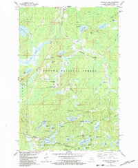
1982 Map of Stateline Lake
USGS Topo · Published 1983About this map
Ottawa National Forest blankets this borderland landscape between Gogebic County, Michigan, and Vilas County, Wisconsin. The terrain is defined by a dense network of glacial lakes and small creeks, where many water bodies bear floral or faunal names like Bluebell Lake, Honeysuckle Lake, and Bobcat Lake. The Chicago and North Western corridor cuts through the northern sections, passing near the settlement of Wellington and several gravel pits, indicating the region's reliance on both timber and rail transport.
Find a feature on this map
67 named features on this map. Tap any name to fly to it.
Don’t see what you’re looking for? This feature index may not catch every label — zoom into the map to look around manually.
Map Details
Editions of this 1982 Stateline Lake Map
This is the sole edition of this map. No revisions or reprints were ever made.
Other maps of this area

1939 · Trout Lake
USGS Topo · 1:48,000

1939 · Winchester
USGS Topo · 1:48,000

1946 · Winchester
USGS Topo · 1:48,000

1946 · Trout Lake
USGS Topo · 1:48,000

1949 · Trout Lake
USGS Topo · 1:48,000

1955 · Marenisco
USGS Topo · 1:62,500

1955 · Boulder Junction
USGS Topo · 1:62,500

1955 · Winchester
USGS Topo · 1:62,500

1955 · Marenisco
USGS Topo · 1:24,000

1955 · Wakefield
USGS Topo · 1:62,500