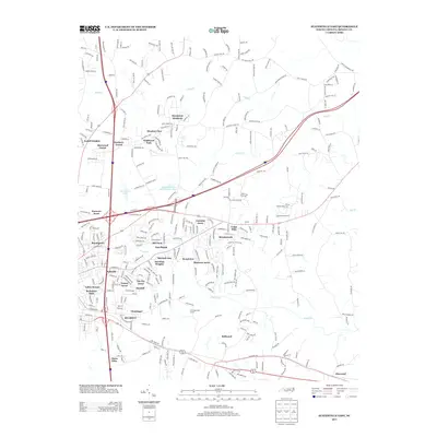
2013 Map of Statesville East
USGS Topo · Published 2013About this map
Belmont and the surrounding residential developments east of Statesville characterize this 2013 portrait of Iredell County. The landscape is defined by the winding paths of Fifth Cr, Beaver Cr, and Fourth Cr, which carve through a dense network of suburban subdivisions and rural neighborhoods. Established communities like Elmwood and Cloaninger sit alongside numerous named housing tracts such as Sherwood Forest, Meadow View, and Camelot Acres, illustrating the steady eastward growth of the city during the early 21st century. Leisure and land use are marked by features like the Twin Oaks Golf Course and several private water bodies, including Hawthorne Lake and Wilson Brothers Lake Number Two. This detailed survey provides a clear view of the area's modern infrastructure, showing the transition from concentrated residential zones to the more open lands near Bellwood and Glenn Echo.
Find a feature on this map
311 named features on this map. Tap any name to fly to it.
Don’t see what you’re looking for? This feature index may not catch every label — zoom into the map to look around manually.
Map Details
Editions of this 2013 Statesville East Map
This is the sole edition of this map. No revisions or reprints were ever made.
Other maps of this area

1893 · Statesville
USGS Topo · 1:125,000

1953 · Charlotte
USGS Topo · 1:250,000

1954 · Charlotte
USGS Topo · 1:250,000

1960 · Charlotte
USGS Topo · 1:250,000

1962 · Charlotte
USGS Topo · 1:250,000

1969 · Cool Springs
USGS Topo · 1:24,000

1969 · Shepherds
USGS Topo · 1:24,000

1969 · Troutman
USGS Topo · 1:24,000
1969 · Harmony
USGS Topo · 1:24,000
1969 · Calahaln
USGS Topo · 1:24,000