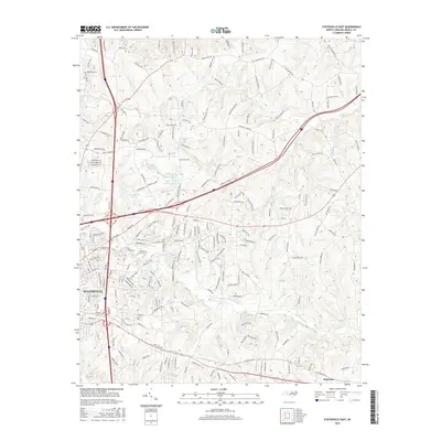
2016 Map of Statesville East
USGS Topo · Published 2016About this map
Statesville serves as the focal point for this Iredell County survey, showing the city's eastern expansion toward the rural landscape. The topography is defined by the drainage basins of Fifth Cr and Fourth Creek, with the prominent elevation of Signal Hill standing between them. This era reveals a transition from traditional agricultural land to residential development, with numerous named roads such as Whites Farm Rd and Jefferson Farm Rd hinting at the area's agrarian heritage. Several private impoundments, including Hatfield Association Lake and the Wilson Brothers Lake complex, dot the terrain, reflecting mid-century water management and recreation patterns. The eastern edge of the map features the smaller community of Elmwood, while the Belmont Cem and various local routes provide essential markers for genealogists tracing family landholdings and historical transit corridors in the region.
Find a feature on this map
203 named features on this map. Tap any name to fly to it.
Don’t see what you’re looking for? This feature index may not catch every label — zoom into the map to look around manually.
Map Details
Editions of this 2016 Statesville East Map
This is the sole edition of this map. No revisions or reprints were ever made.
Other maps of this area

1893 · Statesville
USGS Topo · 1:125,000

1953 · Charlotte
USGS Topo · 1:250,000

1954 · Charlotte
USGS Topo · 1:250,000

1960 · Charlotte
USGS Topo · 1:250,000

1962 · Charlotte
USGS Topo · 1:250,000

1969 · Cool Springs
USGS Topo · 1:24,000

1969 · Shepherds
USGS Topo · 1:24,000

1969 · Troutman
USGS Topo · 1:24,000
1969 · Harmony
USGS Topo · 1:24,000
1969 · Calahaln
USGS Topo · 1:24,000