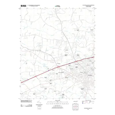
2010 Map of Statesville West
USGS Topo · Published 2010About this map
Statesville and its western suburbs appear as a dense network of residential subdivisions and infrastructure in this early 21st-century record. The landscape is defined by its expansion through neighborhoods like West Statesville, Starmount, and Oakland Heights, as well as older locales such as Monticello and Loray. This period shows a well-developed municipal footprint, including the Statesville Municipal Airport and the Lakewook Golf Course in the south, while the northern sections maintain a more rural character with numerous family-named farms like Summers Farm Rd and Absher Farm Rd.
Find a feature on this map
93 named features on this map. Tap any name to fly to it.
Don’t see what you’re looking for? This feature index may not catch every label — zoom into the map to look around manually.
Map Details
Editions of this 2010 Statesville West Map
This is the sole edition of this map. No revisions or reprints were ever made.
Other maps of this area

1893 · Statesville
USGS Topo · 1:125,000

1895 · Hickory
USGS Topo · 1:125,000

1953 · Charlotte
USGS Topo · 1:250,000

1954 · Charlotte
USGS Topo · 1:250,000

1960 · Charlotte
USGS Topo · 1:250,000

1962 · Charlotte
USGS Topo · 1:250,000

1969 · Shepherds
USGS Topo · 1:24,000

1969 · Troutman
USGS Topo · 1:24,000
1969 · Harmony
USGS Topo · 1:24,000

1969 · Statesville West
USGS Topo · 1:24,000