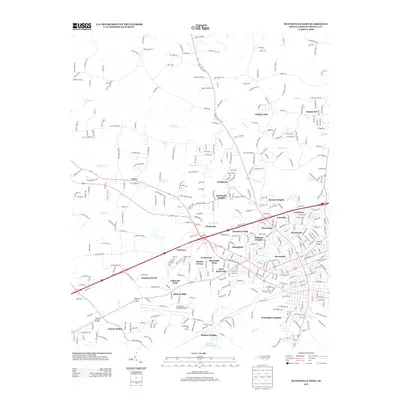
2013 Map of Statesville West
USGS Topo · Published 2013About this map
Statesville Regional Airport serves as a prominent focal point in this section of Iredell County, surrounded by a dense network of suburban developments and industrial corridors. The landscape is defined by the dendritic drainage patterns of Fourth Creek and Morrison Creek, which weave between established neighborhoods like Kingswood, Loray, and Chipley Park. The expansion of the city's western outskirts is evident through numerous named subdivisions such as Westover, Greencrest, and Bostian Heights, reflecting the area's growth as a regional hub. South of the main residential clusters, Kenneth Raymer Lake and the Lakewook Golf Course provide significant recreational footprints. This map captures the intricate road network and the diverse mix of residential, commercial, and aviation infrastructure that characterizes the western edge of the city during the early 21st century.
Find a feature on this map
369 named features on this map. Tap any name to fly to it.
Don’t see what you’re looking for? This feature index may not catch every label — zoom into the map to look around manually.
Map Details
Editions of this 2013 Statesville West Map
This is the sole edition of this map. No revisions or reprints were ever made.
Other maps of this area

1893 · Statesville
USGS Topo · 1:125,000

1895 · Hickory
USGS Topo · 1:125,000

1953 · Charlotte
USGS Topo · 1:250,000

1954 · Charlotte
USGS Topo · 1:250,000

1960 · Charlotte
USGS Topo · 1:250,000

1962 · Charlotte
USGS Topo · 1:250,000

1969 · Shepherds
USGS Topo · 1:24,000

1969 · Troutman
USGS Topo · 1:24,000
1969 · Harmony
USGS Topo · 1:24,000

1969 · Statesville West
USGS Topo · 1:24,000