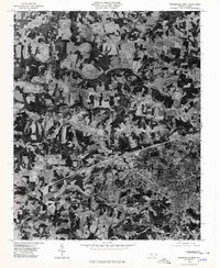
1976 Map of Statesville West
USGS Topo · Published 1979About this map
Statesville and its western outskirts are captured during a period of significant infrastructural expansion in the mid-1970s. This orthophotoquad, based on 1976 aerial photography, reveals the patchwork of agricultural fields and woodlots that then dominated the landscape of western Iredell County. The image provides a clear view of the developing interstate corridor bisecting the terrain between the established community of Loray and the growing residential areas around Celeste Hinkel. The natural drainage of the region is defined by the parallel paths of Third Creek, Fourth Creek, and Fifth Creek, which cut across the landscape from west to east. By using rectified imagery instead of traditional cartographic symbols, the map offers a raw look at land use patterns and forest cover, showing how newer residential subdivisions began to press into the traditional farmland surrounding the town center.
Find a feature on this map
6 named features on this map. Tap any name to fly to it.
Don’t see what you’re looking for? This feature index may not catch every label — zoom into the map to look around manually.
Map Details
Editions of this 1976 Statesville West Map
This is the sole edition of this map. No revisions or reprints were ever made.
Other maps of this area

1893 · Statesville
USGS Topo · 1:125,000

1895 · Hickory
USGS Topo · 1:125,000

1953 · Charlotte
USGS Topo · 1:250,000

1954 · Charlotte
USGS Topo · 1:250,000

1960 · Charlotte
USGS Topo · 1:250,000

1962 · Charlotte
USGS Topo · 1:250,000

1969 · Shepherds
USGS Topo · 1:24,000

1969 · Troutman
USGS Topo · 1:24,000
1969 · Harmony
USGS Topo · 1:24,000

1969 · Statesville West
USGS Topo · 1:24,000