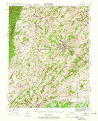
1944 Map of Staunton
USGS Topo · Published 1966About this map
Staunton serves as the central hub of this mid-century survey, situated at the confluence of the Chesapeake and Ohio and Norfolk and Western railroads. The map reveals a landscape defined by its valley drainage systems, where Middle River and Christians Creek carve through the limestone-rich terrain. Rural life is anchored by numerous small parishes and meeting houses such as Jerusalem Chapel, Hebron Ch, and Mt Tabor Ch, which dot the surrounding countryside alongside established family-named landmarks like Castle Spr and Cochran Spr.
Find a feature on this map
77 named features on this map. Tap any name to fly to it.
Don’t see what you’re looking for? This feature index may not catch every label — zoom into the map to look around manually.
Map Details
Editions of this 1944 Staunton Map
2 editions found

Other maps of this area

1892 · Buckingham
USGS Topo · 1:125,000

1892 · Harrisonburg
USGS Topo · 1:125,000

1894 · Staunton
USGS Topo · 1:125,000

1894 · Lexington
USGS Topo · 1:125,000

1924 · Mc Dowell
USGS Topo · 1:62,500

1932 · Lexington
USGS Topo · 1:48,000

1934 · Waynesboro
USGS Topo · 1:48,000

1936 · Vesuvius
USGS Topo · 1:48,000

1937 · Lexington
USGS Topo · 1:62,500

1939 · Waynesboro
USGS Topo · 1:62,500