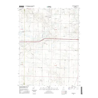
2016 Map of Staunton
USGS Topo · Published 2016About this map
Staunton and Cory anchor this 2016 survey of the borderlands between Vigo and Clay counties. The landscape is defined by its transition from agricultural expanses like Clay Prairie and Wheeler Prairie to the wooded drainages of Birch Creek and Crooked Creek. Transportation corridors such as Bloomington Rd and W Lower Bloomington Rd follow historical routes through the rural townships, connecting smaller crossroads settlements like Art and Turner.
Find a feature on this map
48 named features on this map. Tap any name to fly to it.
Don’t see what you’re looking for? This feature index may not catch every label — zoom into the map to look around manually.
Map Details
Editions of this 2016 Staunton Map
This is the sole edition of this map. No revisions or reprints were ever made.
Other maps of this area

1908 · Clay City
USGS Topo · 1:48,000

1910 · Clay City
USGS Topo · 1:62,500

1940 · Lewis
USGS Topo · 1:24,000

1941 · Seelyville
USGS Topo · 1:24,000

1950 · Rosedale
USGS Topo · 1:24,000

1950 · Brazil East
USGS Topo · 1:24,000

1950 · Brazil West
USGS Topo · 1:24,000
1952 · Lewis
USGS Topo · 1:24,000

1952 · Seelyville
USGS Topo · 1:24,000

1953 · Indianapolis
USGS Topo · 1:250,000