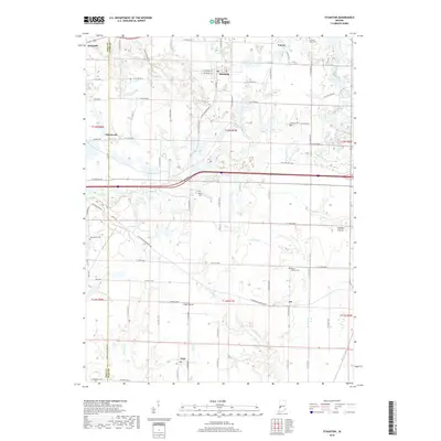
2019 Map of Staunton
USGS Topo · Published 2019About this map
Staunton and Cory anchor this modern survey of the Indiana landscape along the border of Vigo and Clay counties. The terrain is defined by a dense network of small waterways, including Birch Creek, Crooked Cr, and the Big Slough, which drain the flatlands and occasional clearings such as Wheeler Prairie. This area maintains a strong connection to its 19th-century settlement roots through its numerous small burial grounds, such as Mount Calvary Cem and Mewhinney Cem, which remain as landmarks alongside modern thoroughfares like E State Rd 42. Small communities like Cherryvale and Clay Prairie populate the grid of county roads, while the northern edge of the map traces the outskirts of Seelyville. The landscape reflects a mix of persistent agricultural use and the natural drainage patterns of the Wabash Valley region.
Find a feature on this map
53 named features on this map. Tap any name to fly to it.
Don’t see what you’re looking for? This feature index may not catch every label — zoom into the map to look around manually.
Map Details
Editions of this 2019 Staunton Map
This is the sole edition of this map. No revisions or reprints were ever made.
Other maps of this area

1908 · Clay City
USGS Topo · 1:48,000

1910 · Clay City
USGS Topo · 1:62,500

1940 · Lewis
USGS Topo · 1:24,000

1941 · Seelyville
USGS Topo · 1:24,000

1950 · Rosedale
USGS Topo · 1:24,000

1950 · Brazil East
USGS Topo · 1:24,000

1950 · Brazil West
USGS Topo · 1:24,000
1952 · Lewis
USGS Topo · 1:24,000

1952 · Seelyville
USGS Topo · 1:24,000

1953 · Indianapolis
USGS Topo · 1:250,000