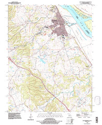
1993 Map of Ste Genevieve
USGS Topo · Published 1996About this map
Ste Genevieve serves as the focal point of this survey, revealing the historical layout of one of Missouri's earliest settlements along the Mississippi River. The landscape is a complex mix of industrial activity and distinct natural features, with the extraction industry represented by the Mississippi Mine, Peerless Mine, and several quarries. The terrain shifts from the low-lying Bois Brule Bottom and Moro Island to the elevated Beckett Hills, where numerous karst features like Kohms Cave and Geller Cave are documented. Smaller settlements such as New Bourbon and Quarry Town reflect the area's distributed growth patterns. Transport and infrastructure are noted through the presence of a Landing Strip and Communication Towers, while local history is preserved at sites like Holy Cross Cemetery.
Find a feature on this map
36 named features on this map. Tap any name to fly to it.
Don’t see what you’re looking for? This feature index may not catch every label — zoom into the map to look around manually.
Map Details
Editions of this 1993 Ste Genevieve Map
This is the sole edition of this map. No revisions or reprints were ever made.
Other maps of this area

1907 · Weingarten
USGS Topo · 1:62,500

1909 · Weingarten
USGS Topo · 1:62,500

1912 · Baldwin
USGS Topo · 1:62,500

1914 · Baldwin
USGS Topo · 1:62,500

1915 · Renault
USGS Topo · 1:62,500

1915 · Chester
USGS Topo · 1:62,500

1940 · Renault
USGS Topo · 1:62,500

1942 · Baldwin
USGS Topo · 1:62,500

1947 · Chester
USGS Topo · 1:62,500

1949 · Saint Louis
USGS Topo · 1:250,000