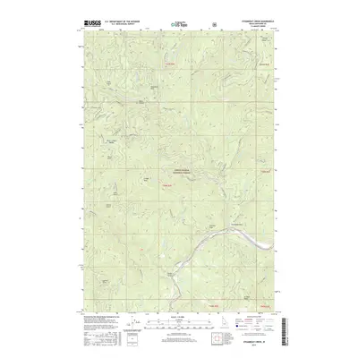
2017 Map of Steamboat Creek
USGS Topo · Published 2017About this map
The North Fork Coeur d'Alene River winds through the southern reaches of the Coeur d'Alene National Forest, defining the drainage patterns of this mountain landscape. In this 2017 study, the intricate network of gulches and draws—including Weyer Gulch, Drew Gulch, and Simmons Draw—illustrates a terrain deeply carved by water. Prominent landmarks like Steamboat Rock and Steamboat Peak overlook a complex of forestry roads and off-highway vehicle tracks, such as Felder OHV and Steamboat OHV, which trace the ridges and valley floors. The presence of Old River Rd along the main waterway suggests long-established access routes through the panhandle. From the heights of Grizzly Ridge to the depths of Black Canyon, the map provides a contemporary record of how resource management and recreation have shaped this portion of Shoshone County.
Find a feature on this map
62 named features on this map. Tap any name to fly to it.
Don’t see what you’re looking for? This feature index may not catch every label — zoom into the map to look around manually.
Map Details
Editions of this 2017 Steamboat Creek Map
This is the sole edition of this map. No revisions or reprints were ever made.
Other maps of this area

1901 · Coeur D'Alene District
USGS Topo · 1:62,500

1903 · Coeur D'Alene District
USGS Topo · 1:62,500

1906 · Coeur D'Alene District
USGS Topo · 1:62,500

1909 · Cataldo
USGS Topo · 1:125,000

1911 · Cataldo
USGS Topo · 1:125,000

1955 · Spokane
USGS Topo · 1:250,000

1957 · Kingston
USGS Topo · 1:62,500

1957 · Kellogg
USGS Topo · 1:62,500

1958 · Spokane
USGS Topo · 1:250,000

1961 · Lakeview
USGS Topo · 1:62,500