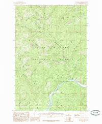
1985 Map of Steamboat Creek
USGS Topo · Published 1985About this map
Coeur D'Alene National Forest dominates this 1985 landscape, defined by the deep canyons and narrow ridges of Idaho's Panhandle. The Coeur D'Alene River winds through the southern portion of the quadrangle, serving as the primary drainage for a dense network of mountain streams. Numerous named water bodies like Big Bob Creek, Eighty Day Creek, and Long Tom Creek illustrate the intricate hydrological patterns of this timber-rich region. High points such as Steamboat Peak and Cougar Peak provide significant vertical relief, with Grizzly Ridge marking the eastern boundary. The absence of major settlements highlights the area's use for forestry and recreation, as evidenced by the Wood Rat Trail. The map provides a detailed view of the terrain before later development or environmental shifts, capturing the watershed's configuration through gulches like Clark Gulch and Drew Gulch.
Find a feature on this map
46 named features on this map. Tap any name to fly to it.
Don’t see what you’re looking for? This feature index may not catch every label — zoom into the map to look around manually.
Map Details
Editions of this 1985 Steamboat Creek Map
This is the sole edition of this map. No revisions or reprints were ever made.
Other maps of this area

1901 · Coeur D'Alene District
USGS Topo · 1:62,500

1903 · Coeur D'Alene District
USGS Topo · 1:62,500

1906 · Coeur D'Alene District
USGS Topo · 1:62,500

1909 · Cataldo
USGS Topo · 1:125,000

1911 · Cataldo
USGS Topo · 1:125,000

1955 · Spokane
USGS Topo · 1:250,000

1957 · Kingston
USGS Topo · 1:62,500

1957 · Kellogg
USGS Topo · 1:62,500

1958 · Spokane
USGS Topo · 1:250,000

1961 · Lakeview
USGS Topo · 1:62,500