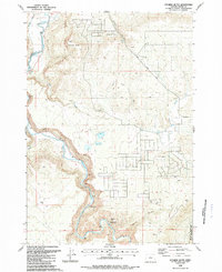
1988 Map of Stearns Butte
USGS Topo · Published 1988About this map
Crooked River dominates this Central Oregon landscape, its serpentine path carved through deep canyons as it flows toward the northwest. The river's flow is heavily managed for irrigation and wildlife, evidenced by a network of water control infrastructure including Stearns Dam, Hoffman Dam, and a Siphon located near various flumes. These features reflect the mid-century engineering efforts to harness the region's limited water resources for agriculture and habitat management.
Find a feature on this map
24 named features on this map. Tap any name to fly to it.
Don’t see what you’re looking for? This feature index may not catch every label — zoom into the map to look around manually.
Map Details
Editions of this 1988 Stearns Butte Map
This is the sole edition of this map. No revisions or reprints were ever made.
Other maps of this area

1946 · Eagle Rock
USGS Topo · 1:62,500

1948 · Eagle Rock
USGS Topo · 1:62,500

1948 · Ochoco Reservoir
USGS Topo · 1:62,500

1950 · Ochoco Reservoir
USGS Topo · 1:62,500

1955 · Bend
USGS Topo · 1:250,000

1957 · Bend
USGS Topo · 1:250,000

1958 · Bend
USGS Topo · 1:250,000

1962 · Huston Lake
USGS Topo · 1:24,000

1962 · Prineville
USGS Topo · 1:24,000

1962 · Powell Buttes
USGS Topo · 1:62,500