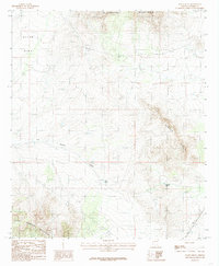
1985 Map of Steele Hills
USGS Topo · Published 1985About this map
The Steele Hills define the central topography of this mid-1980s Arizona landscape, situated in a high-desert basin between several prominent mountain ranges. The northern portion of the map is dominated by the foothills of the Winchester Mountains, while the Little Dragoon Mountains rise to the southwest. This area, largely defined by ranching and open range, is bisected by the Tres Alamos Wash, which serves as a primary drainage corridor for the Allen Flat region. Industrial infrastructure is noted by the presence of a high-voltage Transmission Line and the Trans-Arizona Double Wooden Pole line, marking the modernization of rural Cochise County. Water management in this arid environment is highlighted by features such as Big Tank, reflecting the necessity of seasonal catchments for local livestock operations during this era.
Find a feature on this map
8 named features on this map. Tap any name to fly to it.
Don’t see what you’re looking for? This feature index may not catch every label — zoom into the map to look around manually.
Map Details
Editions of this 1985 Steele Hills Map
This is the sole edition of this map. No revisions or reprints were ever made.
Other maps of this area

1922 · Willcox
USGS Topo · 1:125,000

1943 · Willcox
USGS Topo · 1:62,500

1943 · Cochise
USGS Topo · 1:62,500

1943 · Dragoon
USGS Topo · 1:62,500

1943 · Winchester Mts.
USGS Topo · 1:62,500

1945 · Winchester Mts.
USGS Topo · 1:62,500

1954 · Silver City
USGS Topo · 1:250,000

1956 · Tucson
USGS Topo · 1:250,000

1957 · Winchester Mts.
USGS Topo · 1:62,500

1958 · Silver City
USGS Topo · 1:250,000