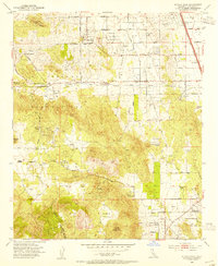
1953 Map of Steele Peak
USGS Topo · Published 1955About this map
Gavilan Mine, Ida-Leona Mine, and the Santa Rosa Mine anchor a landscape defined by early Riverside County resource extraction and agricultural development in the early 1950s. The northern edge of the map is dominated by the industrial-scale infrastructure of the March Air Force Base and the critical Colorado River Aqueduct, which cuts across the terrain near Val Verde. This period captures a shift from mining toward ranching and poultry farming, as evidenced by several named properties such as Rancho El Nido, Rancho Loma de Oro, and the Poultry Ranch. The Atchison Topeka and Santa Fe railroad corridor facilitates movement through the valley, connecting small communities like Glen Valley with rural landmarks such as Bethel Church and the Hartford Springs area.
Find a feature on this map
50 named features on this map. Tap any name to fly to it.
Don’t see what you’re looking for? This feature index may not catch every label — zoom into the map to look around manually.
Map Details
Editions of this 1953 Steele Peak Map
2 editions found
Other maps of this area

1901 · Southern California Sheet No. 1
USGS Topo · 1:250,000

1901 · Elsinore
USGS Topo · 1:125,000

1901 · Riverside
USGS Topo · 1:62,500

1904 · Southern California Sheet No. 1
USGS Topo · 1:250,000

1942 · Lake Elsinore
USGS Topo · 1:62,500
1942 · Riverside and Vicinity
USGS Topo · 1:31,680

1942 · Murrieta
USGS Topo · 1:62,500

1942 · Riverside
USGS Topo · 1:62,500

1942 · Perris
USGS Topo · 1:62,500

1943 · Perris
USGS Topo · 1:62,500