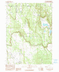
1990 Map of Steele Swamp
USGS Topo · Published 1990About this map
Grohs Ranch and Steele Swamp Ranch sit within a high-elevation landscape defined by the intersection of the Modoc National Forest and Fremont National Forest. This 1990 provisional survey documents the rugged borderlands where California meets Oregon, marked by a series of state boundary monuments from State Bdy Mon #43 to State Bdy Mon #48. The terrain is characterized by broad seasonal basins and drainages, most notably the Steele Swamp and Fourmile Valley. Water management is evident through features like the Fourmile Reservoir and numerous stock ponds, supporting the ranching operations that have long persisted in this remote corner of Modoc County. The map provides a clear record of the hydrological network, including the headwaters of Boles Creek and the meandering path of Willow Creek as it flows past Bird Spring Ridge.
Find a feature on this map
30 named features on this map. Tap any name to fly to it.
Don’t see what you’re looking for? This feature index may not catch every label — zoom into the map to look around manually.
Map Details
Editions of this 1990 Steele Swamp Map
This is the sole edition of this map. No revisions or reprints were ever made.
Other maps of this area

1886 · Alturas
USGS Topo · 1:250,000

1886 · Modoc Lava Bed
USGS Topo · 1:250,000

1889 · Klamath
USGS Topo · 1:250,000

1892 · Modoc Lava-Bed
USGS Topo · 1:250,000

1892 · Alturas
USGS Topo · 1:250,000

1894 · Klamath
USGS Topo · 1:250,000

1951 · Clear Lake Reservoir
USGS Topo · 1:62,500

1954 · Alturas
USGS Topo · 1:250,000

1955 · Klamath Falls
USGS Topo · 1:250,000

1958 · Alturas
USGS Topo · 1:250,000