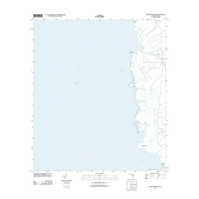
2012 Map of Steinhatchee SW
USGS Topo · Published 2012About this map
Gulf of Mexico waters define the eastern edge of this coastal reach in Dixie County, where a fragmented shoreline of marshy islands and tidal inlets meets the Florida coast. The map illustrates a landscape dominated by intricate water systems including Days Creek, Sink Creek, and Buck Cr, which flow through the low-lying terrain before reaching the sea. Coastal landmarks such as Hardy Point, Bird Island, and Tater Island serve as primary navigational markers for this remote stretch of the Big Bend region. Human infrastructure is sparse, concentrated on the inland edge where Co Hwy 361 and Rock Patch Rd provide the only significant access to the marshes. The geography of Big Grassy Island and Bull Cove reflects a shifting coastal environment where small changes in elevation determine the boundary between solid ground and the open gulf.
Find a feature on this map
15 named features on this map. Tap any name to fly to it.
Don’t see what you’re looking for? This feature index may not catch every label — zoom into the map to look around manually.
Map Details
Editions of this 2012 Steinhatchee SW Map
This is the sole edition of this map. No revisions or reprints were ever made.
Other maps of this area

1954 · Steinhatchee SW
USGS Topo · 1:24,000

1954 · Jena
USGS Topo · 1:24,000

1954 · Steinhatchee
USGS Topo · 1:24,000

1954 · Steinhatchee SE
USGS Topo · 1:24,000

1954 · Horseshoe Beach
USGS Topo · 1:24,000

1954 · Crooked Point
USGS Topo · 1:24,000

1954 · Gainesville
USGS Topo · 1:250,000

1958 · Gainesville
USGS Topo · 1:250,000

1959 · Gainesville
USGS Topo · 1:250,000

1978 · Cedar Keys
USGS Topo · 1:100,000