
1954 Map of Crooked Point
USGS Topo · Published 1956About this map
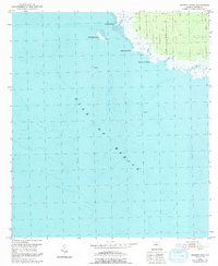
The Gulf of Mexico coast of Taylor County, Florida, is defined here by a low-lying, intricate network of marshlands and tidal creeks. This mid-1950s survey captures the landscape before significant modern development, emphasizing the remote nature of the shoreline at Fishermans Rest. The inland terrain is marked by an Old Railroad Grade that cuts through the forested flats, a relic of the region’s earlier timber and naval stores economy. Several prominent coastal features, such as Crooked Point and Long Grass Point, separate the mainland from the shallow waters where Big Grass Island sits. The drainage pattern is dominated by winding waterways including Crooked Creek, Big Beer Creek, and Clay Creek, which snake through the tidal environment. This map reflects a quiet era for this stretch of the Big Bend, characterized by isolated platforms in the water and a landscape primarily used for seasonal fishing and timber harvesting.
Find a feature on this map
10 named features on this map. Tap any name to fly to it.
Don’t see what you’re looking for? This feature index may not catch every label — zoom into the map to look around manually.
Map Details
Editions of this 1954 Crooked Point Map
2 editions found
Other maps of this area

1954 · Steinhatchee SW
USGS Topo · 1:24,000

1954 · Salem SW
USGS Topo · 1:24,000

1954 · Steinhatchee
USGS Topo · 1:24,000

1954 · Keaton Beach
USGS Topo · 1:24,000

1954 · Gainesville
USGS Topo · 1:250,000

1958 · Gainesville
USGS Topo · 1:250,000

1959 · Gainesville
USGS Topo · 1:250,000
1978 · Cross City
USGS Topo · 1:100,000
2012 · Salem SW
USGS Topo · 1:24,000
2012 · Steinhatchee
USGS Topo · 1:24,000