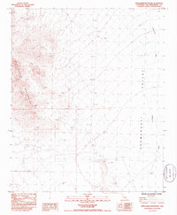
1985 Map of Stepladder Mountains
USGS Topo · Published 1985About this map
The Stepladder Mountains dominate the western portion of this San Bernardino County survey, giving way to the broad expanse of the Chemehuevi Valley to the east. This arid landscape is defined by its drainage patterns, most notably the Chemehuevi Wash which meanders through the eastern flats. Human activity in the mid-1980s was largely limited to remote desert travel and early exploration, evidenced by a network of 4wd tracks and evidence of former prospecting. Traces of historical effort are visible at the site of Ruins and a labeled Prospect located near the mountain base, suggesting a history of mineral exploration in the shadow of the peaks. The map provides a detailed view of these remote features before modern technological changes shifted the way these desert environments are navigated.
Find a feature on this map
8 named features on this map. Tap any name to fly to it.
Don’t see what you’re looking for? This feature index may not catch every label — zoom into the map to look around manually.
Map Details
Editions of this 1985 Stepladder Mountains Map
This is the sole edition of this map. No revisions or reprints were ever made.
Other maps of this area

1903 · Needles
USGS Topo · 1:125,000

1904 · Needles Special
USGS Topo · 1:125,000

1943 · Center Hills
USGS Topo · 1:62,500

1943 · Turtle Mts.
USGS Topo · 1:62,500

1950 · Sawtooth Range
USGS Topo · 1:62,500

1950 · Savahia Peak
USGS Topo · 1:62,500

1951 · Savahia Peak
USGS Topo · 1:62,500

1951 · Sawtooth Range
USGS Topo · 1:62,500

1954 · Needles
USGS Topo · 1:250,000

1954 · Turtle Mountains
USGS Topo · 1:62,500