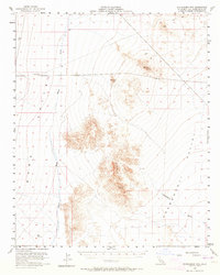
1956 Map of Stepladder Mts
USGS Topo · Published 1964About this map
The Stepladder Mts dominate this mid-century survey, rising sharply from the surrounding desert floor between Homer Wash and Chemehuevi Wash. This arid landscape, documented in the 1950s, reveals a sparse industrial presence defined by mining and utility infrastructure. A north-south Pipeline cuts across the northern flats, while evidence of extraction is found at the Shafts near the high point of Big Chief. These peaks provided critical vantage points for early surveyors, evidenced by several triangulation stations like Chief and Conical. A lonely Jeep Trail in the north and a Beacon suggest the area’s role in navigation and travel through the remote San Bernardino County backcountry. The map captures a moment when the rugged interior of the Ward Valley was accessed primarily by high-clearance vehicles and surveying teams.
Find a feature on this map
14 named features on this map. Tap any name to fly to it.
Don’t see what you’re looking for? This feature index may not catch every label — zoom into the map to look around manually.
Map Details
Editions of this 1956 Stepladder Mts Map
3 editions found
Other maps of this area

1903 · Needles
USGS Topo · 1:125,000

1904 · Needles Special
USGS Topo · 1:125,000

1942 · Amboy
USGS Topo · 1:250,000

1943 · Center Hills
USGS Topo · 1:62,500

1943 · Amboy
USGS Topo · 1:250,000

1943 · Essex
USGS Topo · 1:62,500

1943 · Fenner
USGS Topo · 1:62,500

1943 · Bannock
USGS Topo · 1:62,500

1943 · Turtle Mts.
USGS Topo · 1:62,500

1950 · Sawtooth Range
USGS Topo · 1:62,500