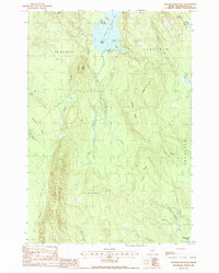
1988 Map of Stetson Mountain
USGS Topo · Published 1988About this map
Stetson Mountain dominates the western interior of this Washington County landscape, which transitions between high ridgelines and the sprawling wetland systems of the northern Maine woods. The northern boundary is defined by the deep waters of Upper Hot Brook Lake, featuring named points such as Long Pt and Dark Pt, as well as Kittery Island. The presence of several Gravel Pits suggests localized resource extraction within the townships of Danforth and Brookton.
Find a feature on this map
37 named features on this map. Tap any name to fly to it.
Don’t see what you’re looking for? This feature index may not catch every label — zoom into the map to look around manually.
Map Details
Editions of this 1988 Stetson Mountain Map
This is the sole edition of this map. No revisions or reprints were ever made.
Other maps of this area

1931 · Springfield
USGS Topo · 1:48,000

1934 · Springfield
USGS Topo · 1:62,500

1940 · Danforth
USGS Topo · 1:62,500

1941 · Danforth
USGS Topo · 1:62,500

1941 · Scraggly Lake
USGS Topo · 1:62,500

1941 · Wytopitlock
USGS Topo · 1:62,500

1943 · Danforth
USGS Topo · 1:62,500

1943 · Wytopitlock
USGS Topo · 1:62,500

1944 · Scraggly Lake
USGS Topo · 1:62,500

1954 · Millinocket
USGS Topo · 1:250,000