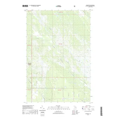
2019 Map of Steuben NE
USGS Topo · Published 2019About this map
Hiawatha National Forest dominates this section of the Upper Peninsula, where a complex network of truck trails and forest roads crisscrosses a landscape defined by wetlands and winding watercourses. The northern reaches are shaped by the NW Br Manistique River and several small tributaries like Hickey Creek and Section Nineteen Creek. Further south, the drainage basin of Stutts Creek meanders through the forest, flanked by Bear Slough and Hay Meadow Creek. The presence of the Haywire Grade Ath suggests a rail-to-trail conversion of an old logging line, while local names such as Mint Farm Road hint at the area's agricultural history. Scattered throughout the southern portion of the quadrangle are localized water bodies including Ashford Lake, Trout Lake, and Aldrich Lake, providing a clear record of the glacial hydrology characteristic of Schoolcraft County.
Find a feature on this map
33 named features on this map. Tap any name to fly to it.
Don’t see what you’re looking for? This feature index may not catch every label — zoom into the map to look around manually.
Map Details
Editions of this 2019 Steuben NE Map
This is the sole edition of this map. No revisions or reprints were ever made.
Other maps of this area

1931 · Steuben SE
USGS Topo · 1:31,680

1931 · Steuben SW
USGS Topo · 1:31,680

1931 · Steuben NE
USGS Topo · 1:31,680

1931 · Shingleton SW
USGS Topo · 1:31,680

1931 · Steuben NW
USGS Topo · 1:31,680

1931 · Manistique River NW
USGS Topo · 1:31,680

1931 · Shingleton SE
USGS Topo · 1:31,680

1931 · Manistique River SW
USGS Topo · 1:31,680

1931 · Driggs Lake SW
USGS Topo · 1:31,680

1958 · Shingleton
USGS Topo · 1:62,500